
|
 Information portal about all European guided public transportation systems. This site is regularly updated.
 |
Hamburg METRO (photo N.2/8 [KB 108] 768 x 576pixels)

By KMJ (German Wikipedia) [GFDL (http://www.gnu.org/copyleft/fdl.html) or CC-BY-SA-3.0 (http://creativecommons.org/licenses/by-sa/3.0/)], via Wikimedia Commons
|
select a city: |
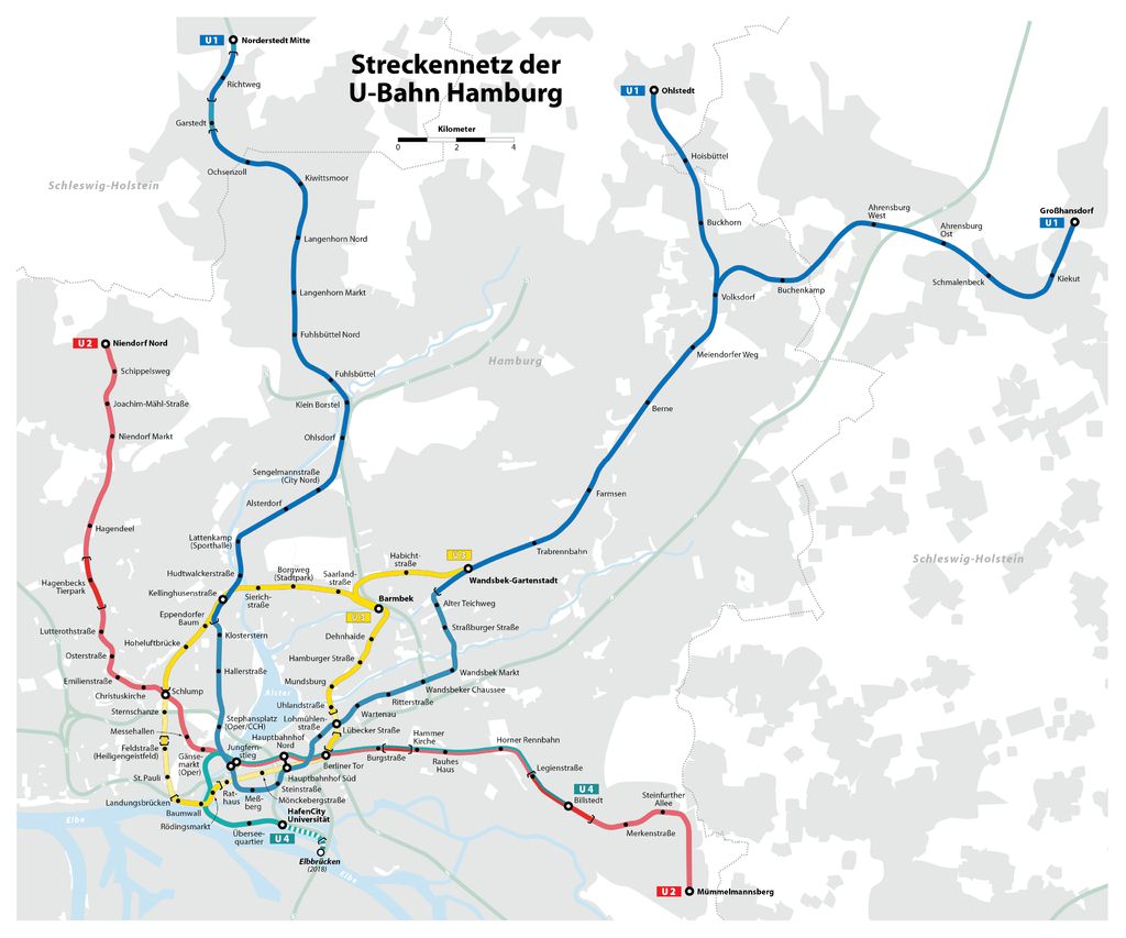
DESCRIPTION (last modified February 19, 2017 )Hamburg transit system inlcludes an urban metro network (U-Bahn) and a suburban railway network (S-Bahn). The first metro section (which is currently part of line U3) opened in 1912 (Rathaus-Barmbek); it was followed in 1915 by Kellinghusenstrasse-Ohlsdorf (now part of U1), Schlump-Hellkamp (U2; Hellkamp former terminal - located between Oster and Lutterothstrasse - was abandoned years later) and Hauptbahnhof-Rothenburgsort (which has been subsequently included in the S-Bahn network). Other sections were added in 1934 ("Langenhorner Bahn": Ohlsdorf-Ochsenzoll [now part of U1]; "KellJung-Linie": Kellinghusenstrasse-Jungfernstieg [now part of U1]; "Walddorferbahn": Barmbek-Grosshansdorf/Ohlstedt [now included in U2 and U1]). The whole U-Bahn network was heavly damaged during the second world war (Hauptbahnhof-Rothenburgsort section was temporally interrupted). The subsequent reconstruction was followed by further extensions of the current U1 (1960: Messberg-Hauptbahnhof; 1962: Hauptbahnhof-Wandsbek Markt; 1963: Wandsbek Markt-Wandsbek Gartenstadt) and U2 (1962: Billstedt-Lutterothstrasse; 1966: Lutterothstrasse-Hagenbecks Tierpark; 1967: Berliner Tor-Horner Rennbahn-Legienstrasse; 1969: Legienstrasse-Billstedt; 1970: Billstedt-Merkenstrasse). The direct connection to the city centre was assured by the completion of new segments: Schlump-Berliner Tor section (U3, 1968), Schlump-Gansemarkt (U2, 1970) and Gansemarkt-Jungfernstieg (U2, 1973). The U-Bahn network reached its current asset during years '80s and '90s, with further extensions: new stretches of U2 (1983: Hagenbecks Tierpark-Niendorf Markt, extended up to Niendorf Nord in 1991; 2009: Berliner Tor-Mummelmannsberg), U3 (1990: Merkenstrasse-Mummelmannsberg) and U1 (1996: Garstedt-Norderstedt Mitte) were continuously added. A fourth line (U4), was planned during years '70s; many alternatives were considered during the long period before the beginning of its construction (2007). U4 opened in 2012 (Jungfernstieg-Uberseequartier) and it was extended in 2013 (Uberseequartier-HafenCity Universitat): this line connects the docks area (HafenCity) with the city centre, joining U2 track at Jungfernstieg and prosecuting in track-sharing with U2 up to Billsted, via Hauptbahnhof and Berliner Tor.
|
LATEST UPDATES TO THIS SITE
| apm | 19-02-2017 |
| lrt-tram | 27-06-2018 |
| metro | 26-06-2018 | funicular | 20-02-2017 | news | 20-02-2017 |
Total size of this site MB 268
www.metrotram.it, v. 5.0
Ing. Michele Tarozzi - (© 2005-2024)


